Indicators and Quartz reefs
+17
Claws
tezz
slimpickens
goldenhero
someday
Digginerup
Aussiedetecting
Jakmagic
Auger
Bushed-Tracker
Peteren
Detrackozi
fcltd
GoldstalkerGPX
Tributer
garretace150
buck06
21 posters
Page 1 of 3
Page 1 of 3 • 1, 2, 3 
 Indicators and Quartz reefs
Just wondering if any of you folks have ever came across an 'indicator' line or even seen one while out prospecting? (Reef / hard rock mining)
It had me stumped for awhile how if - most quartz (not all) reefs run roughly in a NNW - SSE in Victoria and 'Indicator' lines run in this same direction, how could they meet ?
Because when a indicator line intersects a quartz reef gold is found.
I was then informed by a knowledgeable chap that most quartz reefs have 'spurs, fingers, veins, offshoots' which formed outwards and away from the main reef in any direction, it is these that and 'indicator line' could meet. The old fellas called these smaller quartz offshoots 'Leaders' because they 'led' them to the main reef.
I did find once a quartz specimen water-worn, the size of a emu egg which had a small black 'graphite' intrusion (like a pencil lead) in the side of it, my detector said there was something inside. I broke it open and right in the center of the quartz was a small gold nugget the size of a match head, it was completely sealed in. I went back and searched the area but could not find another like it. Thinking back I should have kept it whole.
Scott .
Guest- Guest
 Re: Indicators and Quartz reefs
Gday Scott
When you say "indicator lines" what exactly are you refering to?, do you mean fault lines or shear zones, as being visible indicators of the past activity of the area.
cheers
stayyerAU
When you say "indicator lines" what exactly are you refering to?, do you mean fault lines or shear zones, as being visible indicators of the past activity of the area.
cheers
stayyerAU
Guest- Guest
 Re: Indicators and Quartz reefs
From my understanding in quartz reef mining, the miners came across these Indicator lines which were small veins of pyrites or thin layers of slate. Around Maryborough, the formation was known as Book Leaf slate (because it resembled the pages of a book). Further to the west (Ararat) the Indicator line resembled a pencil line drawn through the earth.
These lines were no wider than the width of a man's finger.
Scott.
These lines were no wider than the width of a man's finger.
Scott.
Guest- Guest
 Re: Indicators and Quartz reefs
i am probly wrong a indicator to me is where the old blokes had dug a deep shaft normaly at the top of a hill down to the right deph then at aprox point down the hill before the gully thats where thay started prospecting. nornaly you will see them and all around the hill at that point there are digs till thay find the right side of the hill this is only my thinking on indicators if any body has any other thoughts on this it would be great 

 cheers buck

buck06- Seasoned Contributor

- Number of posts : 168
Registration date : 2009-01-14
 Re: Indicators and Quartz reefs
Just wondering how can native tree's be an indicator for gold brearing area? 
garretace150- Good Contributor

- Number of posts : 86
Age : 38
Registration date : 2009-10-25
 Re: Indicators and Quartz reefs
Hi scott. My understanding is that an indicator (in 1800's mining terms) is any mineral or geological feature, eg a specific type of vein, fault, that is known to indicate the presence of gold in that area(the indicator often contains small traces of gold along its length). The idea is they know that a certain coloured/mineralized rock bed/vein produces gold in that area. They simply follow that layer (usually a thin vertically bedded layer) either on the surface of the ground or by mining hoping to find a gold rich section.
In a real sense it usually involved looking for a specific sized, mineralized & textured quartz vein by following the line of strike from existing spots where gold was found in the vein (or often a swarm of veins).
In modern terms very specific minerals or combinations of minerals are used by mining companies to hone in on desired mineralisation sites. eg there are specific minerals that indicate there are/or were kimberlite pipes around.
Garretace- Certain trees/plants prefer certain soil/nutrient/Ph conditions. Mineralisation can result in different vegetation growing on it. Even the health of the trees can be effected by the minerals in the soil. Through false colour/infrared aerial and satellite imaging it is possible to detect the change in vegetation health and possible mineral target sites. I remember seeing a number of mining articles about vege showing mineralization sites however most of the papers are probably only available on the web as abstracts unless you wish to purchase them. For the prospector on the ground however i use vegetation to indicate where ground may be shallower or to follow contours around slopes at the level where gold may be found. I have heard of certain species indicating the presence of rotted out kaolin clay rich quartz veins.
Tributer

Tributer- Contributor Plus

- Number of posts : 1006
Registration date : 2008-10-27
 Re: Indicators and Quartz reefs
Hi All, An 'Indicator' is refered to many things now days such as, quartz with ironstone, changes in the colour of the ground, dips and changes in elevations of slope, changes in rock types etc etc.
The true indicator or where the term indicator came from was in Ballarat where a father and son were mining and the 15 year old son discovered or realised that the thin black line (as described in the first post here) was associated with gold deposits. I am under the impression that this black line in carbon and filtered water etc carring gold and filtered it and this is why the gold deposits can be found here. This then beacame realised that when one found and indicator this is what they followed.
Garretace, native trees and plants can be associated with gold deposits (not in all cases) because many of these vegatations grow in highly mineralised ground only, or some grasses that will be growing in one area or clump may indicate an area that had a hollow or dip and over time has filled with wash and thus collecting gold deposits.
Cheers
GoldstalkerGPX- Contributor Plus

- Number of posts : 1732
Age : 100
Registration date : 2009-07-27
 Re: Indicators and Quartz reefs
All good replies to 'indicators'.
Tributer and GoldstalkerGPX 'Good on you!', both good explanations and a willingness to share your knowledge.
Thanks
Scott.
Tributer and GoldstalkerGPX 'Good on you!', both good explanations and a willingness to share your knowledge.
Thanks
Scott.
Guest- Guest
 Re: Indicators and Quartz reefs
Thanks guys. I was a little unsure why native tree's would indicate a gold spot but now i no. Will keep that in mind when im out in the field!
garretace150- Good Contributor

- Number of posts : 86
Age : 38
Registration date : 2009-10-25
 Re: Indicators and Quartz reefs
Gday
There are many things that could be considered as indicators, but it seems that in this case the reference is to a form of indicator that was common to that particular area, and there would have been similar things that the old timers recognised in other areas.
The subject of vegetation indicating mineral deposits is very interesting, and I have noted that in some areas that I have found gold there are sometimes particular trees and shrubs that seem more abundant than they are elsewhere, not that this necessarily indicates the presence of gold but it could indicate the presence of a lot of minerals that make up the composition of the ground that these particular plants find to their liking and it allows them to thrive.
Observation is the key, the subject is known as geobotanical prospecting, and has been around forever, in the very early days ancient people like the Mayans possibly would have very closely inspected the mounds of ants and other ground boring creatures to see what the compositon was of the dirt that they had brought to the surface, just as we now inspect rabbit warrens and the like to see if they may have kicked out a nuggy or two, lots of gold has been found in this way.
There are other indicators such as the density of the scrub in particular areas indicating deeper ground, or a line of trees or shrubs following an old creek bed and fault line, when you are observing an area that is reasonably well populated with vegetation and then you can see either a line of stunted growth or areas of little or no growth then it indicates that the ground is shallow with little or no topsoil, this would indicate the possible presence of a reef just below the surface so it should be more closely inspected.
The old timers recognised many of these things and a combination of several of these features would have caused them to stop and have a closer look, and pehaps either sample the surrounding stone or carry out some loaming to see if any gold was present.
cheers
stayyerAU
Guest- Guest
 Re: Indicators and Quartz reefs
this may help shed some light on the sebject
https://www.youtube.com/watch?v=lxjMWJQAgdY
https://www.youtube.com/watch?v=lxjMWJQAgdY
fcltd- New Poster

- Number of posts : 19
Registration date : 2009-05-13
 Re: Indicators and Quartz reefs
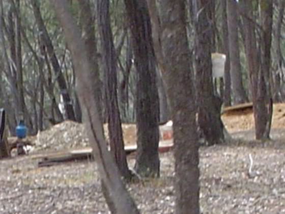
It was all just a shoot of Gold off the main line to the East and no more was found but you should never disregaurd a gold bearing reef line like that one if it has had a shoot like that there would be more it is well worth a chase along the line the claim was surrended.


Detrackozi- Contributor Plus

- Number of posts : 1098
Registration date : 2008-10-27
 Re: Indicators and Quartz reefs
I think I found what could be termed an indicator some years ago
In the Minelab 170000 days I found some nice gold all over a small hill which had a deep mineshaft sunk vertically at the top of the hill.
This shaft was centred on the junction of a small quartz reef and a line of ironstone which intersected at 90 deg.
When the SD range came out the gold kept coming off this hill for some time before the pickings got thin and I started looking along the reef lines for the source. I think the old timers got the source with the shaft but about 3m away ran a very small quartz line in parallel with the main reef.
Detecting along this one day I got a nice mellow deep signal right at the intersection of the small reef and the ironstone line.
About a foot down the gold started to come out in small sharp pieces with quartz and ironstone attached to most of the bits. The gold ran vertically down the intersection of the two reefs and went down another foot before it petered out to nothing. All up 3.5 ounces came out of the one hole in detectable bits and after panning all the dirt another 2/3 of an ounce was gained.
This gold had obviously formed at both of the intersections with the small line of gold that I found possibly being an indicator of the larger source that the old timers dug up.

Peteren- Seasoned Contributor

- Number of posts : 148
Age : 66
Registration date : 2010-10-12
 Re: Indicators and Quartz reefs
hi all would like to know what the indicators are for rushwoth quartz reefs besides saddle reefs and iron in quartz
manny thanks gold finding
manny thanks gold finding
Guest- Guest
 Re: Indicators and Quartz reefs
Certainly 'Indicator Minerals' are the prime target when prospecting for diamonds, ilmenite, garnet, spinels,amd chrome diopsides etc, they are usually found in association with Kimberlites but less so with Lamporites. Aerial photos can often show up changes in the vegetation as well as other surface features such as depressions etc. Once we had discovered the original kimberlitic pipes that formed the Orapa diamond mines in Botswana - they stood out like 'dogs balls' from the air - once we knew thay were there 
 As stated above, changes in vegetation could be due to changed mineralisation, nutrients, ph and changes in the water table. Some kimberlites have shown to support a perched water table for example.
Other changes have been as varied as just studying the topography, or even the density of termite mounds in a specific area. You may well have seen clusters of termite mounds and wondered why they concentrated there? In Africa we sampled termite mounds as some of the local termites burrowed down to the water table and brought up the equivalent of an unsorted drill core to the surface. Diamonds as well as diamond indicator minerals have been seen and recovered from these mounds. Pity they did not dig through hard rock in their search for a drink. Be interesting to pan out some samples of termite mounds in areas where alluvial or elluvial fine gold is found.
John
Bushed-Tracker- Contributor Plus

- Number of posts : 221
Registration date : 2009-03-20
 Re: Indicators and Quartz reefs
I found the best description of gold geological indicators is in The Victorian Prospectors Guide and Handbook. The name comes from the first being called "The Indicator" which was a thin continuous bed that was often associated with gold where it intersected a quartz vein (in the Ballarat area ?). From what I understand it seems to be most useful AFTER gold had been located because it then allowed the old-timers to chase other likely spots nearby.
The frustrating part for me was to find that an indicator can be different for other areas. John Tully (maps) shows a specific name for (eg.) the "White & De Santis" indicator at Shoots Lead (near Dunolly etc). The Vic' Guide & HB (as above/here) lists that indicator as an "iron oxide vein" and the character of the associated bed as "pitted blue or green slate with laminated quartz". However, most of the twenty or so indicators listed (Vic. only) are also "iron oxide vein" with a few of "pyritic seam" and one "black seam". They also say that fault planes/slips can also be indicators.
Hope this helps - Phil

Auger- Contributor Plus

- Number of posts : 426
Registration date : 2012-06-14
 Re: Indicators and Quartz reefs
thanks heaps for the great imfo  but what would the indicators be for rushworth vic ?
Guest- Guest
 It's all about the structure
Grab a note book and pen before you watch this gentleman's youtube postings.
Such a wealth of information and a willingness to share. I take my hat off to this gentleman.
Enjoy
Cb.
Guest- Guest
 Re: Indicators and Quartz reefs
This guy has given me lots of superb tip! Thanks. Do you know his YouTube name? Would like to see his other vids 
Jakmagic- New Poster

- Number of posts : 2
Registration date : 2012-12-24
 Re: Indicators and Quartz reefs
I often think "how many lines of gold have been destroyed by newbies finding ,they think ,random nuggets some where and not having the knowalage to prospect the shedding correctly" 
Just watched that vid and it should be the bible of what to do when out prospecting !!! It doesn't matter whether you wet mine as I do or use a detector ,they are only tools, it's the knowalage that makes the difference but this only comes for 3 things ,practice,practice and more practice ! But a word to the wise you will not become a prospector by reading alone as there are to many variances in the hunt for the yellow !
It was interesting to see this prospector although using a metal detector he also used a pan to loam the soil !
So in the coming new year all those who have the urge to hit the goldfields like a scattergun my advise is to slow down ,certainly read up on the area you are going to prospect but get the basics of prospecting down pat and always prospect a spot meticulously every time .
Guest- Guest
 Re: Indicators and Quartz reefs
His youtube 'handle' is BogiZemlja
below is his channel
https://www.youtube.com/user/BogiZemlja?feature=watch
enjoy & learn
Cb.
below is his channel
https://www.youtube.com/user/BogiZemlja?feature=watch
enjoy & learn
Cb.
Guest- Guest
 Re: Indicators and Quartz reefs
Thanks for sharing that Clay Base. That's a great vid.
I found an abandoned mine that was worked in the 1850's. I took these pics as I found them as an interesting example of indicators.


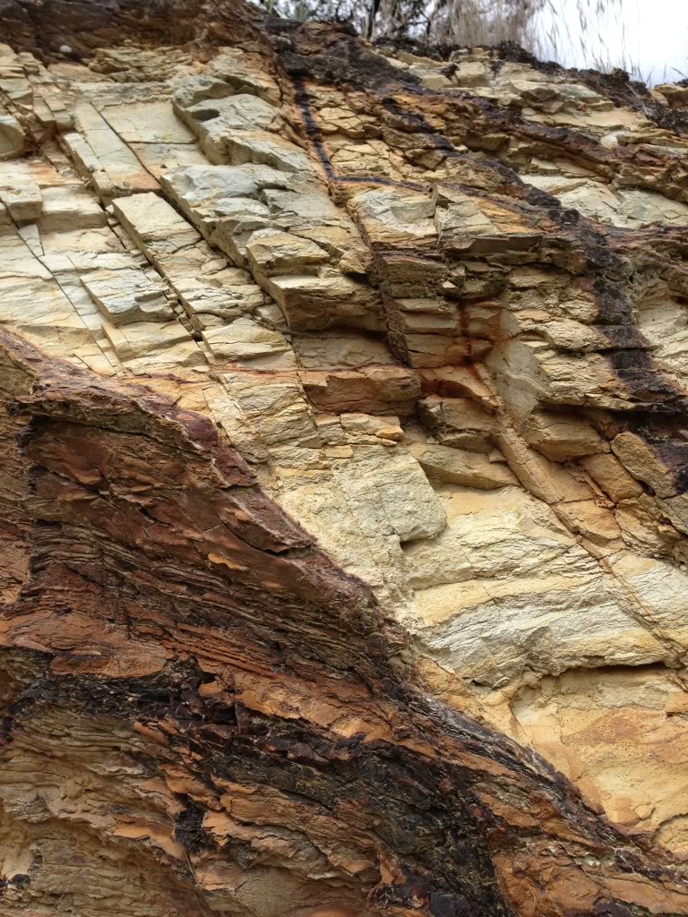
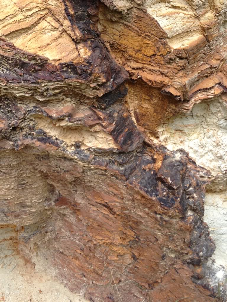
I found an abandoned mine that was worked in the 1850's. I took these pics as I found them as an interesting example of indicators.


Aussiedetecting- Contributor Plus

- Number of posts : 294
Registration date : 2011-10-25
 Re: Indicators and Quartz reefs
Nope Bendigo 

Aussiedetecting- Contributor Plus

- Number of posts : 294
Registration date : 2011-10-25
 Re: Indicators and Quartz reefs
This will be good. ??

Aussiedetecting- Contributor Plus

- Number of posts : 294
Registration date : 2011-10-25
 Re: Indicators and Quartz reefs
Research ! Common ! I'm not gona handit to ya on a plate ! 

Guest- Guest
 Re: Indicators and Quartz reefs
The true meaning of indicators referred to by miners in the 1800's is this. In the Ballaarat area indicators are pencil thin carbon lines in the ground which can run laterally for miles and go to great depths. In other areas such as Dunolly these indicators are very thin metosomatic quartz veins, heavily mineralised with ironstone and other minerals. These indicators do not hold gold themselves, but where these indicator veins intersect quartz reefs they usually form deposits of gold. (nuggets). They are usually dead straight where they cross the ground. The average thickness of an indicator is 1/8th of an inch or less.
Many years ago I was able to get reports from the Dept. of Mines that were written in the 1800's about these indicators. Some very old maps do show these indicators eg. White and Desantis indicator near Dunolly. If you are half smart you can find the locations of these indicators and still chase them by digging very small trenches across the strike and following them. I have some pieces of a metosomatic quartz vein which I will photograph and post here.The thing with indicators that the old timers found useful was that if a large nugget was found near the surface, and evidence of an indicator was present, then then by sinking a shaft on that spot they may find another nugget below, if the indicator is intersected by a quartz vein.
Most of the big nuggets found in the Golden Triangle are "indicator" gold.
The way the nuggets are formed as a result of indicators usually means that you may find a big nugget and nothing else. The Hand of Faith found years ago is a classic example of this. One monster nugget, and nothing else, the same as the "Welcome Stranger" found at Moliagul. Ironbark trees, vegetation, rusty quartz veins all give a general idea of possible gold bearing ground, but are not "true indicators" as described by the Old Timers.
Hope this clears things up a bit.
Guest- Guest
 Re: Indicators and Quartz reefs
Ahh that's very good info indeed ! But not the exact answer I was looking for! 
Guest- Guest
Page 1 of 3 • 1, 2, 3 
 Similar topics
» Black Quartz in reefs, oldtimers called it MAGPIE QUARTZ
» The golden quartz reefs of Australia
» quartz reefs northward from Eaglehawk
» gold bearing quartz reefs occur on a series of magnetic meridians,
» Finding a Quartz Blow and boulders of Quartz
» The golden quartz reefs of Australia
» quartz reefs northward from Eaglehawk
» gold bearing quartz reefs occur on a series of magnetic meridians,
» Finding a Quartz Blow and boulders of Quartz
Page 1 of 3
Permissions in this forum:
You cannot reply to topics in this forum