
Enfield maps
3 posters
Page 1 of 1

Enfield maps
![]() Tickski46 Tue Nov 22, 2022 6:34 pm
Tickski46 Tue Nov 22, 2022 6:34 pm
Gday all, just wondering if anyone has some decent maps of Enfield area for panning. Looking to head up there soon while there’s still a bit of water around
Tickski46- New Poster

- Number of posts : 2
Registration date : 2022-11-21
Re: Enfield maps
![]() avon g Wed Nov 23, 2022 11:05 am
avon g Wed Nov 23, 2022 11:05 am
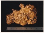
The Signal Smythesdale and Linton gold map covers some of the Enfield State Park around Staffordshire Reef, but stops short of Enfield proper so nothing around the Colac-Ballarat Road.
Other than that there's this:
Other than that there's this:
avon g- Seasoned Contributor

- Number of posts : 174
Registration date : 2012-03-07
Re: Enfield maps
![]() Reg Wilson Sat Nov 26, 2022 7:14 pm
Reg Wilson Sat Nov 26, 2022 7:14 pm
Tickski46, did you know that gold traces were found at Mt Sabine, Gellibrand and a creek near Moonlight head?
For panning near Enfield I would try the Misery creek below O'Keefe's Indicator.
For panning near Enfield I would try the Misery creek below O'Keefe's Indicator.
Reg Wilson- Contributor Plus

- Number of posts : 624
Age : 76
Registration date : 2012-05-14
» Aus Geology Travel Maps (with WA, Qld, NSW & Vic gold-tenement maps)
» Maps Victorian goldfields geological maps
» Enfield State Park
» Hey Peter (mariner 3800) found your avitars brother!
» The Enfield Gold-field.
» Maps Victorian goldfields geological maps
» Enfield State Park
» Hey Peter (mariner 3800) found your avitars brother!
» The Enfield Gold-field.
Page 1 of 1
Permissions in this forum:
You cannot reply to topics in this forum