
Narrowing the odds
+5
Driller
Pennyweight
gollstar
chopppacalamari
Kon61gold
9 posters
Page 1 of 1

Narrowing down the Odds
![]() Guest Fri Jul 17, 2009 10:37 pm
Guest Fri Jul 17, 2009 10:37 pm
How can we recognise where the ground is prospective for nuggets?
That is, recognise the 0.25% of the region that is prospective for nugget
gold & avoid the 99.75% of the ground that isn’t.
Well by concentrating on the 0.25% of the region that is prospective for nugget gold you have already increased your chances of success 400-fold.
What is needed is to find not just the occasional nugget but to find large numbers of nuggets in relatively small, well contained areas, i.e., we need to
find nugget patches.
What is a nugget patch?
A nugget patch may be defined as a population, grouping or accumulation of nuggets in a well defined area surrounded by barren countryside relatively depleted in nugget gold.
A nugget patch can vary considerably in total gold inventory and the numbers, sizes and distribution of contained nuggets. Nugget patches can varying from only
a few small nuggets, very locally distributed; to many tens to hundreds of nuggets comprising several kilograms in combined weight, spread over several tens to hundreds of square meters.
How can we find these areas of gold enrichment & nugget patches?
Look at the abundant freely available sources of information on where
gold has been found already.Particularly the Geological Survey 1:100,000 maps.
What makes an area prospective for detecting
1. existing mining activities nearby or active or former tenements
2. signs of exploration – RAB drill chips, survey grids, costeans, prospector diggings, dry
blowings, previous detector holes, soil geochem sample pegs,
3. reports of previous nugget discoveries
4. laterite caps or pisolitic debris being shed from dolerite areas, or active mining regions
5. streams or gullies draining known gold catchment areas
6. areas where such streams or gullies join tributaries or enter salt lake systems
7. areas where public access soil geochemistry data maps indicate anomalies (even if
nothing eventuated at those anomalies).
8. areas of repeated salt lake evaporation and inundation
9. evidence of significant oxidation and surface weathering
10. evidence of significant iron (and to a lesser extent manganese) enrichment, geothite
and laterite development, iron caps, iron pisolite zones
11. evidence of calcrete development in the soil horizon
12. evidence of groundwater channel ways (shears zones, deep leads), particularly where
there may have been significant dilution of saline ground waters with fresher water.
13. formation of carbonate or sulphate salt zones in the soil, weathering profile, and in salt
lake environments
Exploring well established gold areas with existing or old mines & workings.
Permission from any existing tenement holders is required.
Better still, areas where geochemical soil assay
data is available that identifies local gold concentration & enrichments.
Guest- Guest
Re: Narrowing the odds
![]() Kon61gold Sat Jul 18, 2009 2:21 pm
Kon61gold Sat Jul 18, 2009 2:21 pm
Thanks Gypsy.
Whilst the indications are relevant to nugget finding everywhere, a lot of which you noted do relate to WA.
We have members from all states and overseas, I wonder how they would find a nugget patch relative to their area?
Jeff
Whilst the indications are relevant to nugget finding everywhere, a lot of which you noted do relate to WA.
We have members from all states and overseas, I wonder how they would find a nugget patch relative to their area?
Jeff

Kon61gold- Management
- Number of posts : 4509
Age : 62
Registration date : 2008-10-16 -

geochemical soil assays
![]() Guest Fri Jul 24, 2009 11:17 am
Guest Fri Jul 24, 2009 11:17 am
Hi Gypsy,
I've seen the assays from drill holes in ASX company notes but as you know they are "down hole"assays, i was wondering if you have seen surface readings where they test the top metre, i have heard they do them but as yet havn't seen them posted.
Regards Ron
I've seen the assays from drill holes in ASX company notes but as you know they are "down hole"assays, i was wondering if you have seen surface readings where they test the top metre, i have heard they do them but as yet havn't seen them posted.
Regards Ron
Guest- Guest
Re: Narrowing the odds
![]() chopppacalamari Fri Jul 24, 2009 8:54 pm
chopppacalamari Fri Jul 24, 2009 8:54 pm
OK say you are researching a particular area and going over old mining lease reports, from DIGS, as I do. Each expired lease report is available to us. I like to download the "first annual report" and the 6th and final report. It might not be the sixth but if it says its the final you know it will have a summary of all the work they did over the years without having to read them all. The first annual report usually has a summary of all work carried out on the claim by the previous companies who had leases over the area in the past.
Then I scan the headings in the report. Any Auger soil samples are usually less than 2 metres deep. Hand auger samples are not deep at all and are within detector range most of the time from what i've seen. you can go through the results sheets and see where the anomoly was and go from there. The fire assay results give readings which are in Parts Per Million, so they might get an anomoly that is just dissolved gold in the soil which is not big enough for detectors. You really need to read all the report. Some give up GPS co-ords for me and some have good maps about where they are. One even had property owners names so I could lookem up in the phone book instead of driving there to say hi and ask permission. You will still need permission from the owners of the current exploration licence as well.
I've only been searching results from places where there were mines in the old days. The ones I have visited so far have all been picked bare of gold bearing ore from around the tailing piles. Not one speck of quartz remained. I hope they are not all like that. These all have records indicating they were worked during the depression so in those days they would have tried exceptionally hard to get every speck. Still there would have to be a virgin patch o nuggets out there somewhere.
I keep a close eye on "stream sediment samles" results as well.
Dicko..
chopppacalamari- Contributor Plus

- Number of posts : 660
Registration date : 2008-12-13
Re: Narrowing the odds
![]() Guest Fri Jul 24, 2009 10:57 pm
Guest Fri Jul 24, 2009 10:57 pm
hi,
when im on WAMEX i populate the search word list with "soil sampling" "stream sediment" and metal detecting
then when i click search exploration reports every geo report in WA that have done this type of sampling on their leases will be displayed,
if you need some help with it let me know and ill do up a picture tuturial.
cheers
Gypsy
Guest- Guest
gollstar- Contributor Plus
- Number of posts : 697
Registration date : 2009-04-15
wamex
![]() Guest Sat Jul 25, 2009 12:00 pm
Guest Sat Jul 25, 2009 12:00 pm
Hi All,
Great stuff, I'm heading over to have a look now, thanks!!
Great stuff, I'm heading over to have a look now, thanks!!
Guest- Guest
Exploration Co sampling
![]() Pennyweight Sun Jul 26, 2009 10:36 pm
Pennyweight Sun Jul 26, 2009 10:36 pm
Ron,
the top metre of drill holes are almost never assayed and sometimes if the alluvial soil (regolith) is deep, many metres may not be assayed. This is because the assays may be 'tainted' by alluvial/eluvial gold values. Only until the hard rock is encountered, is any assay taken. Often only quartz, Fe oxide or sulphide mineral samples are assayed. Each assay costs $30 these days and many hundreds are taken per drill program, very expensive!
Much more useful are the soil geochem assays. Remember, 1ppm equates to 1 gram gold per tonne of dirt. Very good grade...often nuggetty gold accompanies higher results such as this so take note. PM208 and PM209 are the common gold fire assays done for soil geochem. If you see these codes, pay attention. Often the results are reduced to ppb (parts per billion) to make the numbers more attractive...bit of a 'con job' for the uninformed investor Anything over 500ppb is very interesting to me!
Cheers, Dwt
the top metre of drill holes are almost never assayed and sometimes if the alluvial soil (regolith) is deep, many metres may not be assayed. This is because the assays may be 'tainted' by alluvial/eluvial gold values. Only until the hard rock is encountered, is any assay taken. Often only quartz, Fe oxide or sulphide mineral samples are assayed. Each assay costs $30 these days and many hundreds are taken per drill program, very expensive!
Much more useful are the soil geochem assays. Remember, 1ppm equates to 1 gram gold per tonne of dirt. Very good grade...often nuggetty gold accompanies higher results such as this so take note. PM208 and PM209 are the common gold fire assays done for soil geochem. If you see these codes, pay attention. Often the results are reduced to ppb (parts per billion) to make the numbers more attractive...bit of a 'con job' for the uninformed investor
Cheers, Dwt

Pennyweight- Seasoned Contributor

- Number of posts : 143
Registration date : 2008-10-22
drill holes
![]() Guest Mon Jul 27, 2009 3:34 pm
Guest Mon Jul 27, 2009 3:34 pm
Hi All,
I checked out tengraph going thru Wamex and the ones i was looking at had no information as to the results of drilling, just that they had drilled ex amount of holes and the costs incurred. Still researching though I'm running out of time, will have another look tonight!!
I checked out tengraph going thru Wamex and the ones i was looking at had no information as to the results of drilling, just that they had drilled ex amount of holes and the costs incurred. Still researching though I'm running out of time, will have another look tonight!!
Guest- Guest
Re: Narrowing the odds
![]() Guest Mon Jul 27, 2009 4:34 pm
Guest Mon Jul 27, 2009 4:34 pm
Hi,
if you want to you can pm or email the areas you are wanting info on and ill see what i can dig up.
cheers
Gypsy
if you want to you can pm or email the areas you are wanting info on and ill see what i can dig up.
cheers
Gypsy
Guest- Guest
Re: Narrowing the odds
![]() Driller Mon Jul 27, 2009 7:39 pm
Driller Mon Jul 27, 2009 7:39 pm
PWT and others,
The top meter of Auger (soil) is always assayed. .
RAB drilling follows up high soil anomalies and sampled at one meter intervals. These are nearly always assayed in 4 mtre compilations from zero onwards to reduce sample cost. Any of these that assay are re-sampled in one meter intervals.
RC drilling is done at one meter intervals and are also assayed in 4m comps, although some people will do one meter samples thru zones of interest and the revert back to 4m comps. Any 4m comps that assay are then re-assayed at one meter intervals.
How do I know this?...............35 years in the Exploration Drilling Industry.
Driller- Contributor

- Number of posts : 70
Registration date : 2008-11-05
drilling results
![]() Guest Mon Jul 27, 2009 9:04 pm
Guest Mon Jul 27, 2009 9:04 pm
Hi driller,
It's good to know from first hand experiences, what a life you have lead, i envy your experience you must have gained while in that job.I gather most of that information these companys get from thier drilling would not be accessable by the public, would you have an insight for us as to whether we can obtain some of this info?.
I have read where some prospectors take samples from all over thier leases and get them assayed, but if the work is already done that info should be stored somewhere, but i havn't worked out how to retrieve this info, it would sure help to have hotspots to walk over instead of just wondering aimlessly.
Meanwhile, I'll keep repairing my yabby pots!!!
Guest- Guest
Re: Narrowing the odds
![]() mulgadansa Mon Jul 27, 2009 11:04 pm
mulgadansa Mon Jul 27, 2009 11:04 pm
Gday Dwt, Au, Gypsy and all
I've often thought about the info that should be available from the thousands of alluvial grab samples you see taken in the past in the bush. Wouldn't it be great if someone collated some of these so that you could see the alluvial anomolies.
I'm sure there are people that have access to this type of company data, I just wish I had the access as well!!!!
Shame it's not more structured so that people could follow up on alluvial leads that are wasted in company data.
cheer
Brett

mulgadansa- Contributor Plus
- Number of posts : 525
Registration date : 2008-10-23
lets try again.
![]() Detrackozi Wed Aug 19, 2009 7:13 pm
Detrackozi Wed Aug 19, 2009 7:13 pm
There is over 2 Million Vic Geochemistry ppm and not all are deep drill samples some are shallow like
(1)Shallow auger soil sample (50mmx100mm hand Auger)
(2)Sieved soil sample
(3)Panned concentrate
(4)Sieved stream sediment samples
Some will look like this Mine-ID 516488 AU Gold 2900.00ppb,Zone54H,E-759716.00,N-5858137.00 Shallow auger soil sample
In Inglewood there is Thousands just like all the other areas we work in the Goldfield.


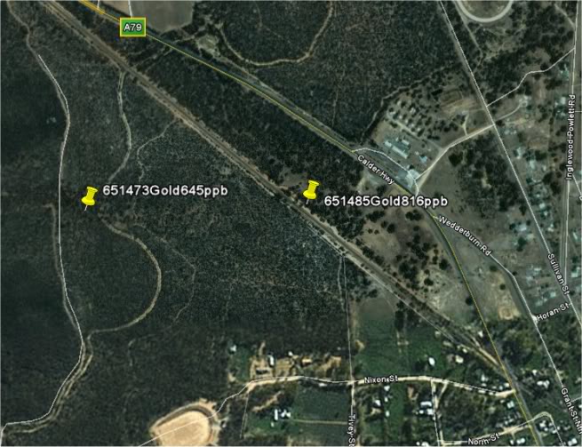
and at the southern end as well


And the great Eastern range have just as mush if not more to offer just look at this reading and it is out of the creek Methed Panned concentrate
Mine-ID464938 AuGold 99500.00ppm,Zone 55H,E-488460.00,N-5918736.00,
Panned concentrate

Looks like a good place to go for a swim this summer would you not say if you can find a spot to laydown.
All those panners and sluice box will be there before you I bet.
David
(1)Shallow auger soil sample (50mmx100mm hand Auger)
(2)Sieved soil sample
(3)Panned concentrate
(4)Sieved stream sediment samples
Some will look like this Mine-ID 516488 AU Gold 2900.00ppb,Zone54H,E-759716.00,N-5858137.00 Shallow auger soil sample
In Inglewood there is Thousands just like all the other areas we work in the Goldfield.
and at the southern end as well
And the great Eastern range have just as mush if not more to offer just look at this reading and it is out of the creek Methed Panned concentrate
Mine-ID464938 AuGold 99500.00ppm,Zone 55H,E-488460.00,N-5918736.00,
Panned concentrate
Looks like a good place to go for a swim this summer would you not say if you can find a spot to laydown.
All those panners and sluice box will be there before you I bet.
David

Detrackozi- Contributor Plus
- Number of posts : 1098
Registration date : 2008-10-27
Gold values
![]() rc62burke Mon Aug 24, 2009 4:24 pm
rc62burke Mon Aug 24, 2009 4:24 pm
500ppb what does this equate to, g/tonne, I have just checked results for stream sediments on 1 of the places I go, 205ppb & 500ppb.Pennyweight wrote:Ron,
the top metre of drill holes are almost never assayed and sometimes if the alluvial soil (regolith) is deep, many metres may not be assayed. This is because the assays may be 'tainted' by alluvial/eluvial gold values. Only until the hard rock is encountered, is any assay taken. Often only quartz, Fe oxide or sulphide mineral samples are assayed. Each assay costs $30 these days and many hundreds are taken per drill program, very expensive!
Much more useful are the soil geochem assays. Remember, 1ppm equates to 1 gram gold per tonne of dirt. Very good grade...often nuggetty gold accompanies higher results such as this so take note. PM208 and PM209 are the common gold fire assays done for soil geochem. If you see these codes, pay attention. Often the results are reduced to ppb (parts per billion) to make the numbers more attractive...bit of a 'con job' for the uninformed investor
Cheers, Dwt
cheers
Lee

rc62burke- Contributor Plus
- Number of posts : 2083
Age : 50
Registration date : 2009-03-05
Re: Narrowing the odds
![]() Nightjar Mon Aug 24, 2009 10:42 pm
Nightjar Mon Aug 24, 2009 10:42 pm
Concentrations of 1000 ppb are equivalent to 1 gram/tonne so 500ppb must be 0.5 gram/tonne?
Pennyweight wrote; "Remember, 1ppm equates to 1 gram gold per tonne "
Trying to get my head around this, do these two equations equate??
Peter
Pennyweight wrote; "Remember, 1ppm equates to 1 gram gold per tonne "
Trying to get my head around this, do these two equations equate??
Peter

Nightjar- Contributor Plus
- Number of posts : 2689
Registration date : 2008-10-25 -
Narrowing the odds
![]() rc62burke Tue Aug 25, 2009 1:54 pm
rc62burke Tue Aug 25, 2009 1:54 pm
Hi all
I have done more research & found gold values of 31 gram/ tonne in mine mullock heaps, now this has my attention, I guess i need to pan some of this dirt to get anidea of the size eg fine / coarse, so I will know if there is detectable gold in the area ( this is from exploration reports).
How would others check this area, pan or small coil ?????
cheers
Lee
rc62burke- Contributor Plus
- Number of posts : 2083
Age : 50
Registration date : 2009-03-05
Re: Narrowing the odds
![]() mulgadansa Thu Aug 27, 2009 9:05 pm
mulgadansa Thu Aug 27, 2009 9:05 pm
Gday Lee
You'd be wasting your time panning I reckon, if this is a mullock dump sample all you'd be doing is recovering the amount of gold that you have in the pan, you can't actually trace it anywhere. Sure, process the whole heap somehow (Bedan Pan, Wolfley Table etc) and recover the gold. At 31 gpt it would be worthwhile if there's 20+tons of the stuff.
At 31 gpt gold is generally visible to the naked eye and I'd guess there would probably be some coarser specimen pieces in that mullock heap that you could target with a detector.
cheers
Brett
mulgadansa- Contributor Plus
- Number of posts : 525
Registration date : 2008-10-23
Page 1 of 1
Permissions in this forum:
You cannot reply to topics in this forum